 CivilNetCheck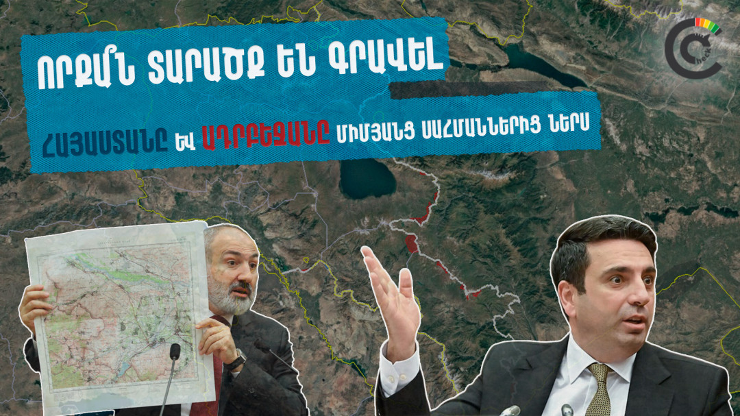
Hayk Hovhannisyan
The Armenian authorities have been facing criticism for negotiating a peace treaty with Azerbaijan while Azerbaijani troops remain stationed on Armenia’s sovereign territory. In response to these claims, Armenian officials have countered that Armenian forces also occupy positions on Azerbaijani land in areas where the border has not been formally delimited.
Most recently, on September 11, 2025 National Assembly Speaker Alen Simonyan told journalists that Armenian troops are stationed on Azerbaijani land, just as Azerbaijani forces are present on Armenian territory. He suggested that Armenia controls approximately 110 square kilometers of de jure Azerbaijani territory, citing the northeastern Tavush region as an example.
#CivilNetCheck conducted an investigation based on open-source data, satellite imagery, and Soviet-era maps to examine how much each side controls the other's territories.
Background: The Armenia-Azerbaijan Border Dispute
Armenia and Azerbaijan have never been formally delimited since both countries gained independence from the Soviet Union in 1991. The situation became further complicated after the 2020 war over Nagorno-Karabakh (known as Artsakh in Armenian), a disputed territory that was internationally recognized as part of Azerbaijan but predominantly populated by ethnic Armenians and controlled by Armenian forces from 1994 to 2020.
Following Azerbaijan's victory in the 44-day war in the fall of 2020, which resulted in Azerbaijan regaining control over significant portions of Nagorno-Karabakh and surrounding territories, a new de facto border was established. According to CivilNetCheck’s calculations, Armenia and Azerbaijan now share an approximately 925-kilometer border. In subsequent years (2021-2022), Azerbaijan conducted several military operations, resulting in Azerbaijani forces advancing into territory that Armenia considers its sovereign land according to Soviet-era maps.
How Borders Are Determined: Maps and Methodology
Our investigation used the 1:100,000 scale topographic maps from the 1970s–1980s designed by the Soviet General Staff as the legal (de jure) border reference. These maps represent the last officially recognized administrative borders between the Armenian and Azerbaijani Soviet Socialist Republics before the USSR's collapse. #CivilNetCheck’s team digitized and overlaid these maps with satellite imagery. The line of actual control (de facto) was determined through contemporary satellite imagery by mapping the frontline combat positions of both countries' armed forces.
These same Soviet General Staff maps are currently used in the ongoing border delimitation process between Armenia and Azerbaijan. Both countries have agreed to use them as the legal basis for determining where the international border should run. Prime Minister Nikol Pashinyan demonstrated one such map to parliament on May 22, 2024, a 1:100,000 scale 1976 General Staff topographic map of the Tavush section—stating that these maps are being applied for delimitation purposes. "...With 19 pages of these maps, we have reproduced the entire perimeter of Armenia's border. Moreover, with de jure documented papers, which is very important," the Prime Minister emphasized.
Our calculations show the surface area of territories where both sides' armed forces have positioned their combat posts beyond the legal border marked on Soviet maps. Notably, the calculations do not include neutral buffer zones between the sides, which, while under observation from elevated positions, are not under either side's physical control. Cases where either side has only a single position on the other's territory are also excluded.
Additionally, the calculations do not include enclave territories. Enclaves are pieces of one country's territory completely surrounded by another country's territory. These include: the Armenian village of Artsvashen (approximately 38 sq. km), which has been under Azerbaijani control since the 1990s, and three Azerbaijani enclaves surrounded by Armenian territory: Yukhari Askipara (approximately 26 sq. km), Barkhudarly-Sofulu (approximately 10 sq. km), and Kyarki/Tigranashen (approximately 8 sq. km). These enclaves existed during the Soviet period and remain points of dispute.
Key Findings
The total length of the de jure border between Armenia and Azerbaijan, including the section with Nakhchivan (an Azerbaijani exclave separated from mainland Azerbaijan by Armenian territory), is approximately 925 kilometers according to our calculations. Along this border, we mapped around 750 Azerbaijani and approximately the same number of Armenian primary combat positions.
According to our study, Armenian forces control approximately 21 square kilometers of Azerbaijan's de jure territory in certain border sections, excluding any enclave territories. This is roughly five times less than National Assembly Speaker Alen Simonyan's claimed figure of approximately 110 square kilometers.
Simultaneously, Azerbaijan's armed forces control at least 241.4 sq. km of Armenia's de jure sovereign territory. They have incursed into Armenia's sovereign territory in approximately 20 sections along the border. Notably, Azerbaijan captured the largest areas during large-scale attacks against Armenia in 2021-2022.
In the interactive map presented below, you can see territories controlled by Armenia (in blue) and Azerbaijan (in red). From the window on the left side, you can also enable the display of combat positions. The white line on the map shows the de jure border reproduced from Soviet General Staff maps, which in some sections does not match the border shown on Google Maps.
After studying the entire border, we identified only nine sections where Armenian armed outposts are clearly on Azerbaijani territory, of which only four involve controlled Azerbaijani territory exceeding one square kilometer. A significant portion of these territories have been under Armenian forces' control since the First Nagorno-Karabakh War (1991-1994).
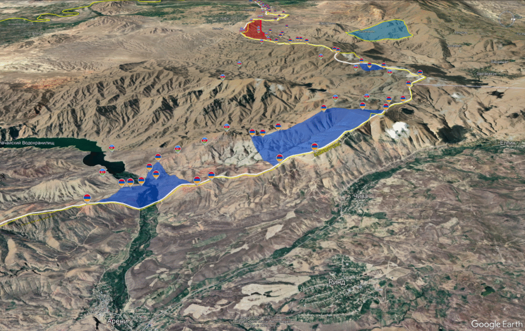
On the border with Nakhchivan, near the villages of Chiva and Areni in the Vayots Dzor region (a mountainous province in southern Armenia), Armenian positions have extended 1-1.5 kilometers into Azerbaijani territory along an approximately 8-kilometer section since the 1990s, occupying about 8.3 square kilometers. The Yerevan-Meghri "M-2" interstate highway, a critical transport route connecting Armenia to Iran, passes through this section.
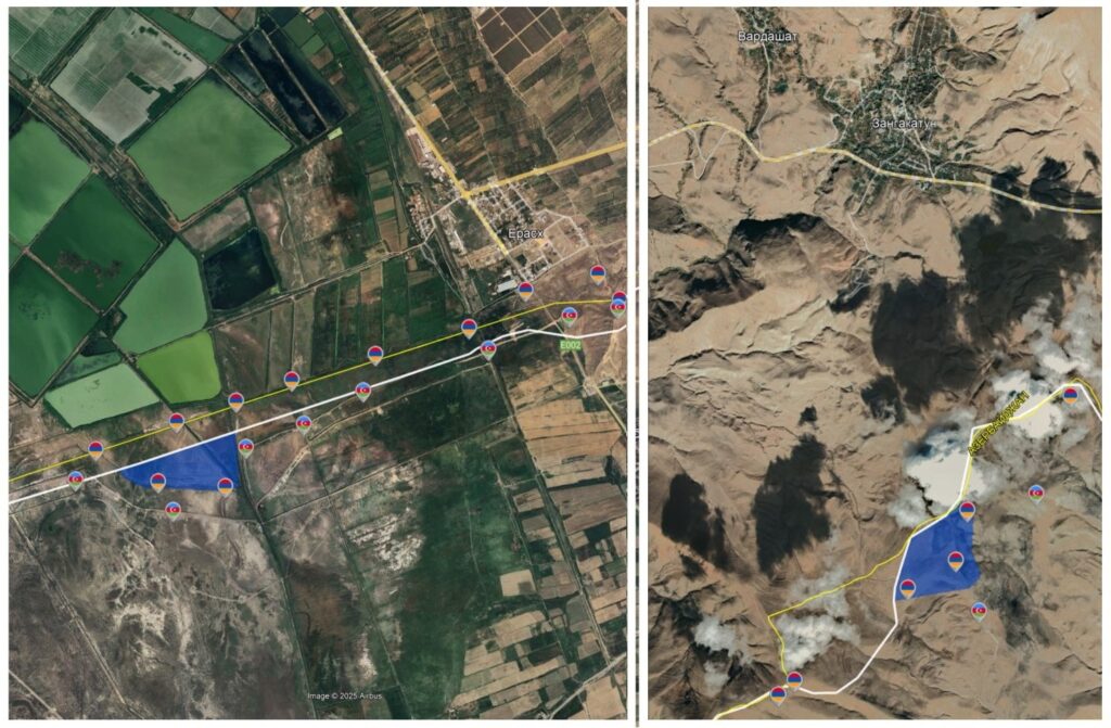
Additionally, in this border zone, Armenian forces control insignificant territories in the Yeraskh and Zangakatun village sections, approximately 0.3 and 0.6 square kilometers respectively.
Another de jure Azerbaijani territory controlled by Armenian forces on the border with Nakhchivan is located west of Kuris-Karchavan villages in the Syunik region (Armenia's southernmost province). Here, several Armenian positions on Mount Khashink (2,689 m) and Mount Kharkhat (2,378 m) are about 1-1.5 kilometers forward toward the Azerbaijani side. They control approximately 4 square kilometers of territory.
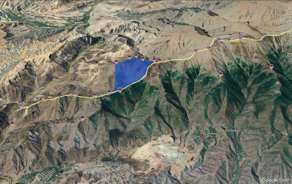
It should be noted that on all other mountain peaks north and south of this border section, Azerbaijan's armed forces have positioned dominant high-ground positions.
Armenian forces also control certain territories in the Tavush region (a northeastern province bordering Azerbaijan). According to Soviet General Staff maps, areas totaling approximately 1.9 square kilometers east of Berdavan village, 4.3 square kilometers adjacent to Voskepar village, and about 0.7 square kilometers northeast of Sargugh are de jure Azerbaijani but remain under Armenian forces' control.
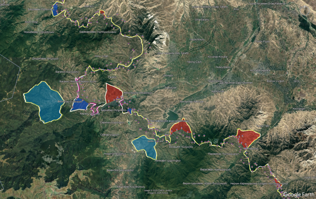
In April 2024, as part of the first phase of border delimitation between Armenia and Azerbaijan along approximately 12.7 kilometers in the Tavush region, Armenia handed over about 6.5 square kilometers of territory (including four former Azerbaijani villages) to Azerbaijan, which had previously been under Armenian control.
At Least 241.4 Square Kilometers of De Jure Armenian Sovereign Territory Under Azerbaijani Control
According to our analysis, as of October 2025, Azerbaijan's armed forces control at least 241.4 square kilometers of Armenia's sovereign territory. Most of this territory came under Azerbaijani control after the 44-day war of 2020, as a result of military aggressions against Armenia. However, some territories, mostly in Tavush, have been under Azerbaijani control since the 1990s.
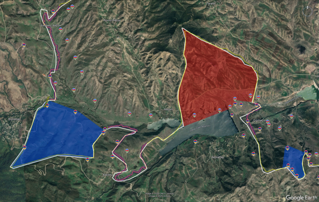
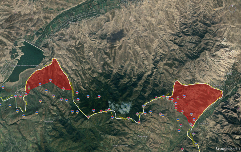
In the Tavush region, Azerbaijan's armed forces control more than 22 square kilometers of territory belonging de jure to Armenia. The largest Armenian territories under Azerbaijani control are in sections adjacent to the villages of Berkaber, Vazashen, and Paravakar.
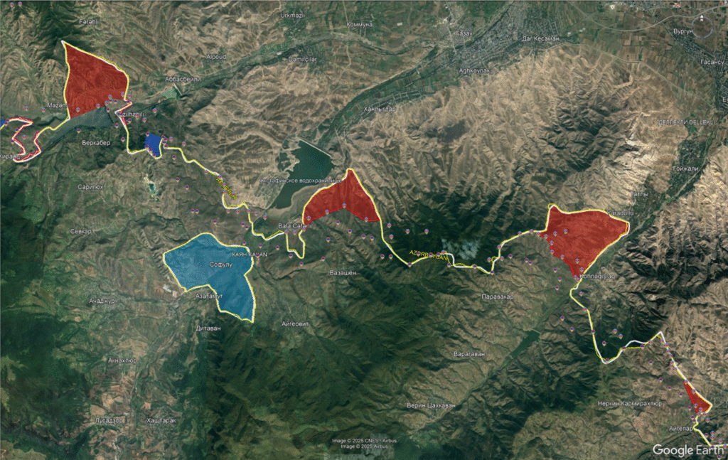
In the northern part of Berkaber, to control the Joghaz reservoir, Azerbaijanis have occupied a "triangular" Armenian territory of 6.3 square kilometers since the 1990s. Four primary Azerbaijani outposts are positioned here, extending about 3 kilometers into Armenian territory.
Interestingly, in this section adjacent to Voskepar village, there is another similar "triangular" territory of 4.3 square kilometers that is de jure Azerbaijani but under Armenian Armed Forces control. For unknown reasons, these two territories were not included in the delimitation process conducted in this section in April 2024.
Similarly, since the 1990s, Azerbaijani forces have occupied territories in the directions of Vazashen and Paravakar. Near Vazashen, Azerbaijan controls 4.5 square kilometers of Armenian territory with a depth of 1-1.5 kilometers and four positions, while in the Paravakar area—7.9 square kilometers with a depth of 3-4 kilometers and eight positions.
In the Tavush region, approximately 0.6 square kilometers of territory north of Barekamavan village is also under Azerbaijani control, as well as about 0.5 square kilometers of Armenian territory near Aygepar. In these border sections, there are two to three Azerbaijani outposts positioned about 500 meters forward into Armenian territory.
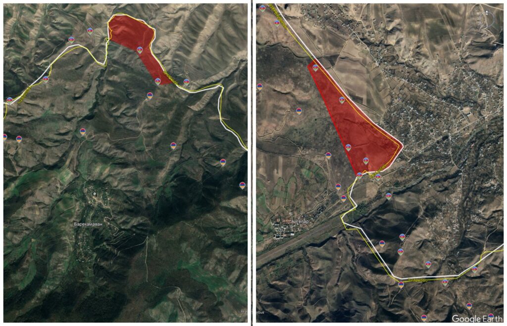
In Tavush, Azerbaijani forces have also captured Armenian territories in several high-ground sections southeast of Aygepar village, with up to ten Azerbaijani outposts. The total area of Armenian territories controlled by Azerbaijan here amounts to approximately 2.5 square kilometers.
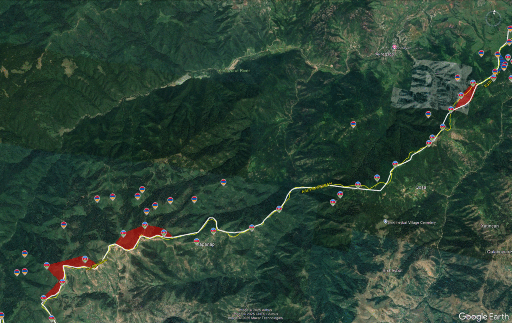
After the 44-day war of 2020 and the passage of the Nagorno-Karabakh territories under Azerbaijani control, Azerbaijani forces positioned themselves along the newly formed Armenian-Azerbaijani border. The war fundamentally changed the regional map: Azerbaijan regained control over territories it had lost in the first Nagorno-Karabakh war (1991-1994), creating a new, largely undefined border between the two countries. Simultaneously, Azerbaijani armed forces conducted several large-scale attacks in 2021-2022, penetrating inside what Armenia considers its internationally recognized borders and occupying a series of territories.
In the Gegharkunik region (Armenia's largest province, surrounding Lake Sevan), Azerbaijani incursions occurred in two main phases: in May 2021 and September 2022. Significant portions of territories adjacent to the villages of Khachakap, Kutakan, Kut, Norabak, and Verin Shorzha, including strategic heights, came under Azerbaijani control.
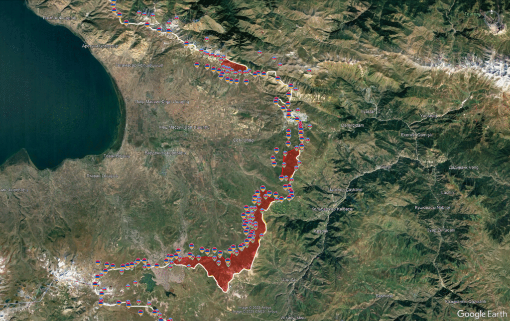
Northeast of Lake Sevan, in the direction of Khachakap-Kutakan villages, Azerbaijan invaded in May 2021 and currently controls approximately 7.9 square kilometers of border territory. It deployed nearly two dozen combat outposts up to 2 kilometers deep into Armenian territory.
In the same period, Azerbaijani forces also invaded the territory adjacent to Kut village, effectively occupying about 9.5 square kilometers in this section and positioning around 5 primary combat positions with a depth of 1.5-2 kilometers.
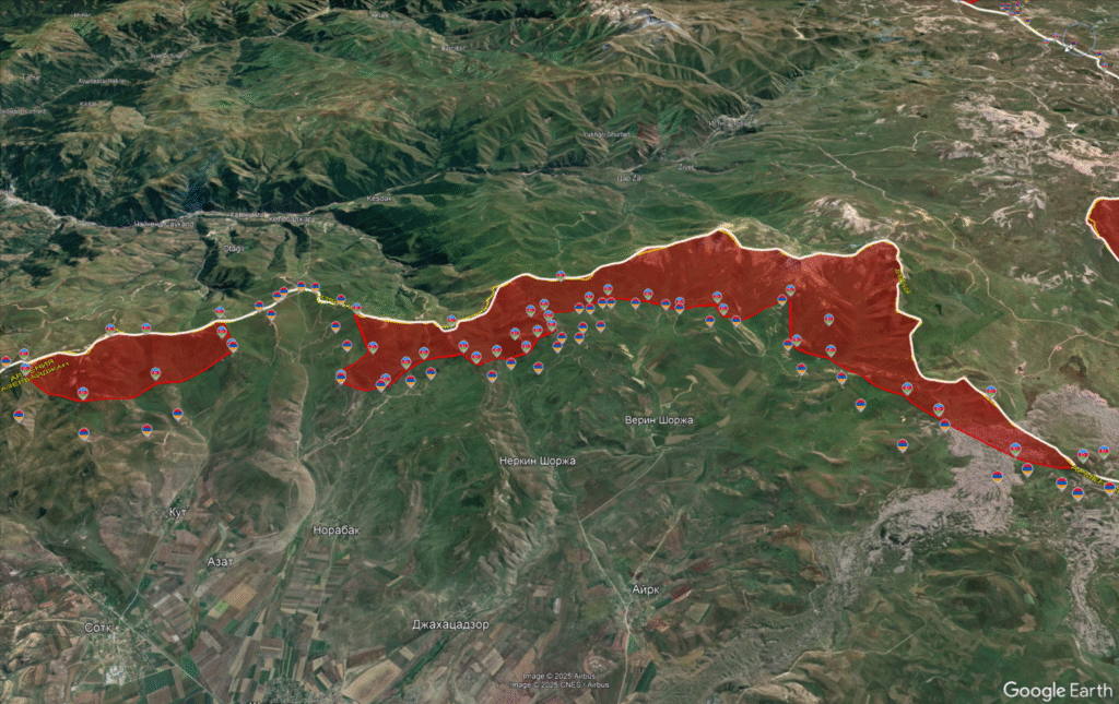
The most significant territorial loss was recorded in the direction of Verin Shorzha, where Azerbaijani forces control more than 49.5 square kilometers of Armenian territory. The incursion here occurred in two phases—in May 2021 and September 2022—and the depth of advancement ranges from several hundred meters to 5 kilometers. Approximately 30 Azerbaijani outposts are positioned inside Armenian territory in this section.
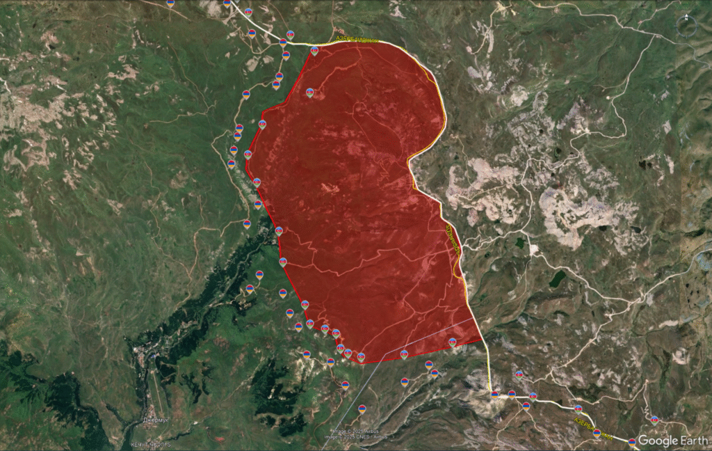
In the Vayots Dzor region, in the direction of Jermuk, Azerbaijan attacked in September 2022 and captured more than 75 square kilometers of territory. The Azerbaijani forces penetrated up to 7.5 kilometers into Armenian territory and captured the chain of heights near the town. Several dozen Azerbaijani positions and fortified outposts are deployed there. This advance brought Azerbaijani forces dangerously close to the city with the civilian population and critical infrastructure.
In the Syunik region, Azerbaijani incursions also occurred in May 2021 and September 2022. Syunik is Armenia's southernmost and strategically critical region—it contains the only land corridor connecting Armenia to Iran and preventing a direct land link between Azerbaijan and Nakhchivan. As a result of these aggressions, Azerbaijan occupied strategically important heights and territories in the northern district of Tsghuk-Spandaryan villages, Mount Ishkhansar, Sev Lich (lake), Nerkin Hand, Shikahog, and several other sections.
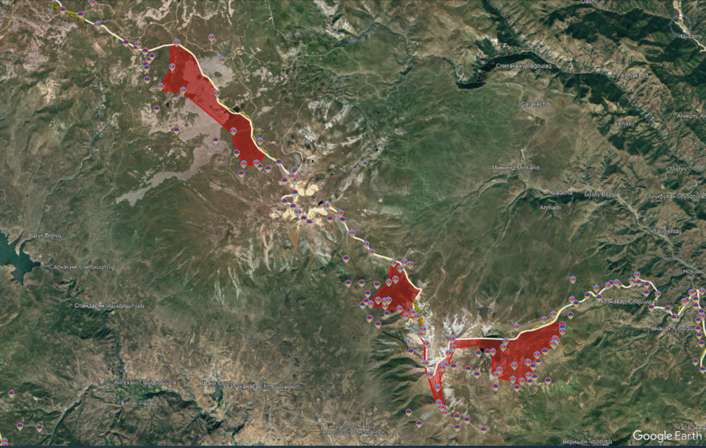
North of Tsghuk-Spandaryan villages, approximately 17 square kilometers of territory is under Azerbaijani control. The incursion occurred in September 2022 as part of a large-scale attack in the direction of Ishkhanasar. The depth of advancement here is about 2 kilometers, with at least six Azerbaijani outposts deployed.
The situation around Mount Ishkhanasar became complicated due to several waves of incursions. Some heights here were occupied by Azerbaijani forces in May 2021, while during the September 2022 aggression, Armenian positions were captured and Armenian territories occupied.
In a separate section north of Ishkhansar, dozens of Azerbaijani outposts control approximately 7.2 square kilometers of Armenian territory, with the advancement depth reaching up to 4 kilometers. On Mount Ishkhanasar itself, Azerbaijan advanced 3 kilometers deep, controlling about 3.5 square kilometers of territory.
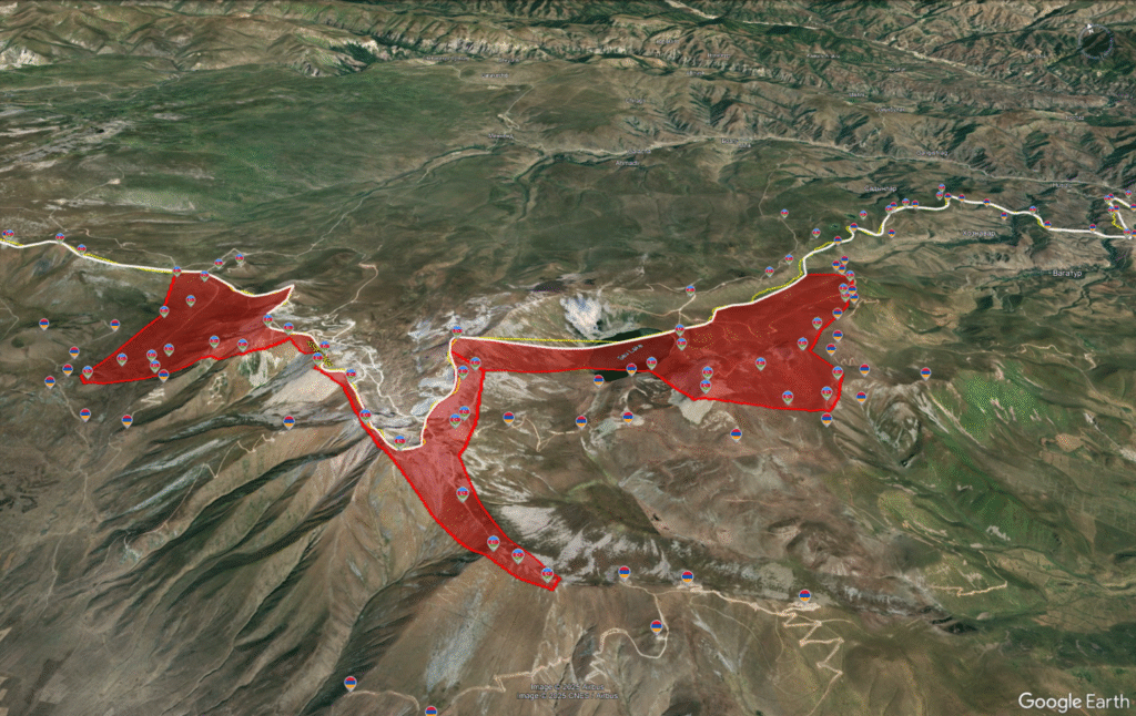
In the Black Lake area, the incursion occurred in May 2021, and since then the Armenian territory controlled by Azerbaijan amounts to 13.9 square kilometers. Updated satellite images from June 2025 show that the advancement depth reaches 3 kilometers, with at least 13 Azerbaijani combat positions deployed.
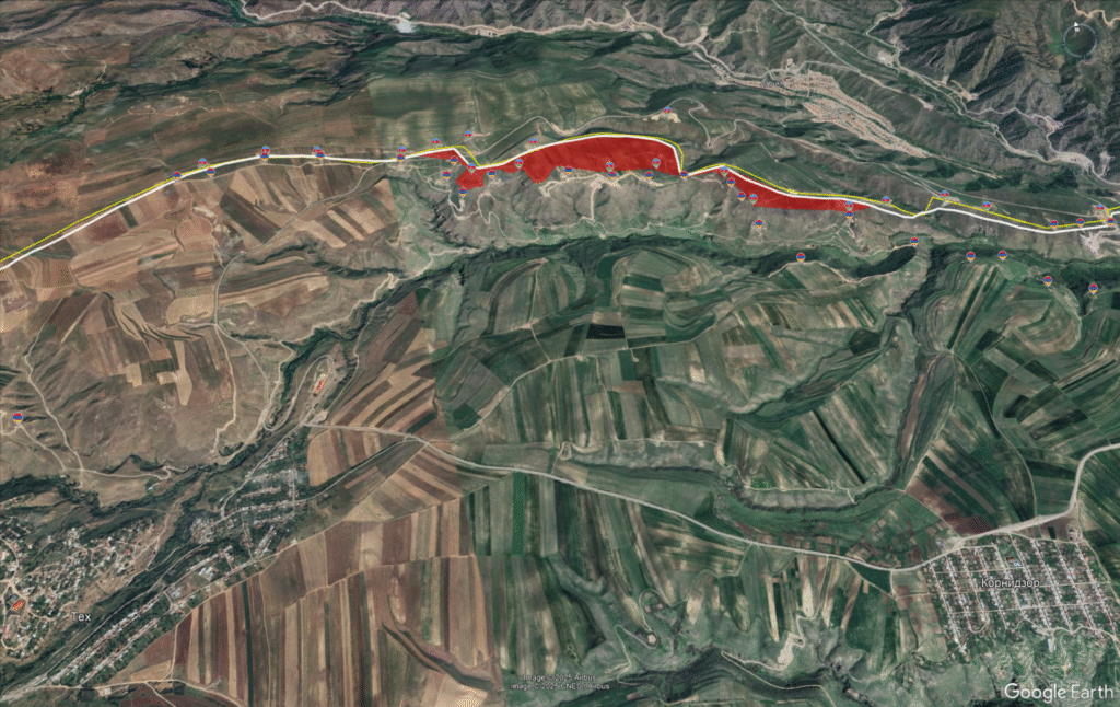
Additionally, in the Tegh-Kornidzor section, Azerbaijani forces are positioned about 300-500 meters beyond the border, effectively capturing approximately 0.7 square kilometers of territory from the Syunik region.
In the Nerkin Hand-Shikahog reserve section south of Kapan, Azerbaijan controls 21.2 square kilometers of territory. The advancement occurred at least from February 2022. Around two dozen Azerbaijani outposts are deployed. The average advancement depth here is about 3 kilometers, including in the Shikahog reserve area, where Azerbaijani armed forces have carried out extensive tree felling.
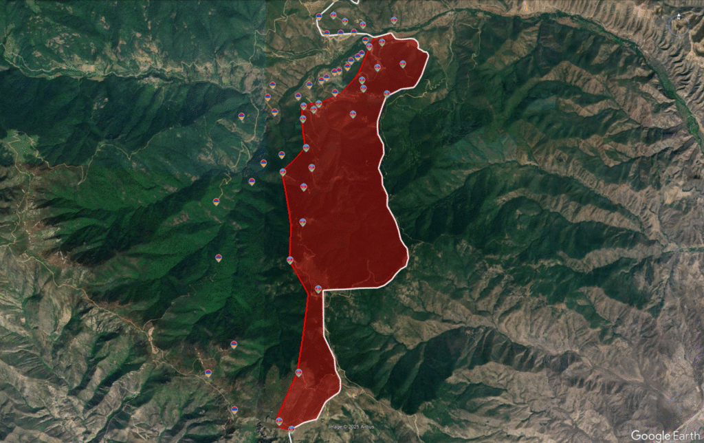
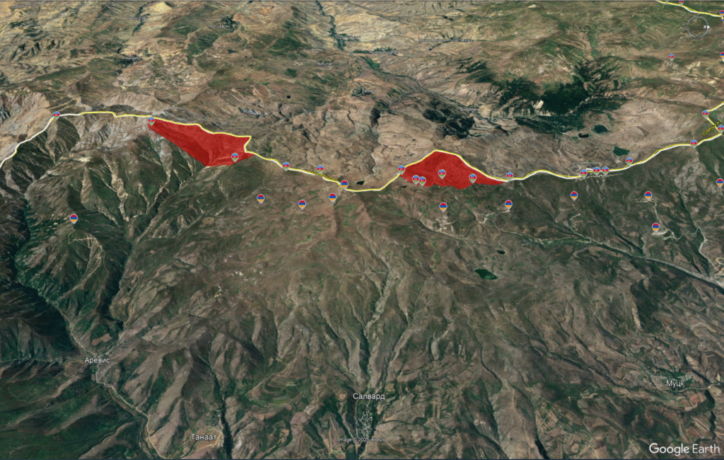
In Syunik, on the border with Nakhchivan, in the direction of Sisian's Arevis and Salvard villages, Azerbaijan's armed forces are 1.5 kilometers forward into Armenian territory, occupying 4.4 square kilometers and 3.5 square kilometers respectively.
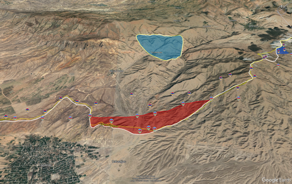
On the border between the Ararat region and Nakhchivan, along the M-5 interstate highway, in the direction of Paruyr Sevak and Tigranashen (Kyarki) villages, Azerbaijan has controlled approximately 5 square kilometers of territory since the 1990s, where four combat positions are deployed about 1 kilometer inside the de jure border, occupying the heights of the area.
Simonyan's Stated Figures Were "Conditional in Nature"
#CivilNetCheck requested clarification from Alen Simonyan regarding the data behind his claim that Armenia controls 110 square kilometers of Azerbaijani territory. The National Assembly press service responded that "the numerical citations made by the Speaker of the National Assembly in the press conference you mentioned are conditional in nature" and represent "merely assumptions made with conditional figures."
Our investigation using open-source data and satellite imagery shows that as of October 2025, at least 241.4 square kilometers of Armenia's sovereign territory is under Azerbaijani control, while approximately 21 square kilometers of Azerbaijani territory is under Armenian forces' control.
The significant imbalance in territorial control—with Azerbaijan controlling more than 11 times as much Armenian territory as Armenia controls Azerbaijani territory—reflects the changed military balance in the region following the 2020 war. The ongoing border delimitation process, which both countries have committed to conducting based on Soviet-era maps, aims to resolve these territorial disputes peacefully.



 Stories